|
||||||||||||||||
 |
||||||||||||||||
|
|
||||||||||||||||
|
||||||||||||||||
|
|
Turkmenistan TurkmenistanArea: 488,100 sq km |
|
Climate: subtropical desertTerrain: flat-to-rolling sandy desert with dunes rising to mountains in the south; low mountains along border with Iran; borders Caspian Sea in westElevation extremes: lowest point: Vpadina Akchanaya -81 m (note—Sarygamysh Koli is a lake in north eastern Turkmenistan whose water levels fluctuate widely; at its shallowest, its level is -110 m; it is presently at -60 m, 20 m above Vpadina Akchanaya) highest point: Ayrybaba 3,139 mGeography—note: landlocked |
Population: 4,366,383 (July 1999 est.) Ethnic groups: Turkmen 77%, Uzbek 9.2%, Russian 6.7%, Kazakh 2%, other 5.1% (1995)Religions: Muslim 89%, Eastern Orthodox 9%, unknown 2%Languages: Turkmen 72%, Russian 12%, Uzbek 9%, other 7% |
| Médecins Sans Frontières has started its fight against tuberculosis in Turkmenistan. See the link to the MSF-website for more information on MSF's activities in Turkmenistan. |
 |
|
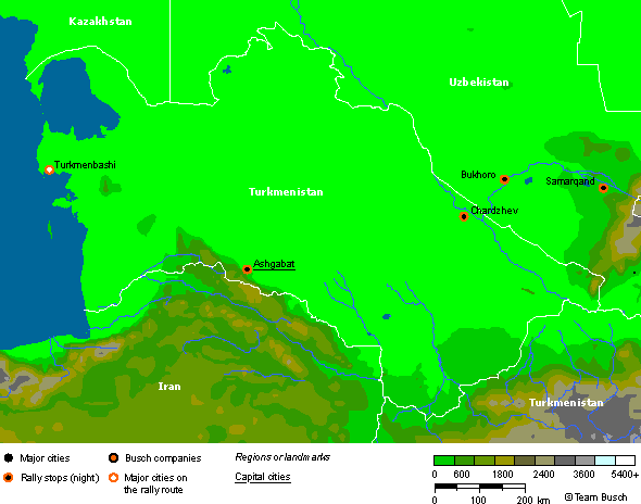
Route notes of the rally: …coming from Azerbaijan. Tuesday 16th May - Day 16 — Disembark at Turkmenbashi on to Ashgabad 575km As we leave Avaza we cross through low hills before starting a long day through desert scenery on one of the sections of the Great Silk Road. However the roads are reasonably good asphalt and the going should be quite fast. First we pass Nebit Dag (Oil Mountain!) then as we get near Ashgabad the mountain range of Kopetdag to the south marks the border with Iran and we begin to see the large areas of cotton cultivation, for which Uzbekistan and Turkmenistan are renowned. Ashgabad is a breeding centre for the Akhal-Teke, a prized racehorse able to maintain its speed in the desert, and also famous for its giant carpets. Wednesday 17th May - Day 17 — Rest Day Ashgabad The route enters the newly independent state of Turkmenistan (October 27th 1991) at Turkmenbashi (old Krasnovodsk). It has an arid desert climate and abundant reserves of natural gas with the Caspian Sea as a backdrop. The President of Turkmenistan, Saparmurat Niyazov, was elected first President on October 27 th 1990. He also refers to himself as Turmenbashi, which mean Head of the Turkmen. Before Tsarist Russia annexed the country in 1884 the Turkmen were a largely nomadic tribal people. Today tribal culture remains strong, with most of the population clustered around desert oases such as Turkmenbashi, Ashgabad and Mari. There is a gentle resurgence of Islam since independence, which ties in with its Muslim neighbours. Thursday 18th May - Day 18 — Ashgabad to Chardzhou 640km From Ashgabad we cross the Karakum desert (Black Sand Desert) passing some areas of dunes with scrub vegetation and many roaming camels along with the sheep and goats. Facilities are few in Turkmenistan and we may see only a few truck stops / local chaikanas (teahouses) along the way. We pass about 40km from fables Merv (now largely raised to the ground) on our way to Chardzhou - the city on the banks of the Amu-Darya (Oxus River) which marks the border with Uzbekistan. Friday 19th May - Day 19 — Chardzhou to Samarkand 400km We cross the Amu Darya on a pontoon bridge and enter Uzbekistan (also independent since 1991) Uzbekistan is the native land of ancient civilisations - the great states of Bactria and Khoresm, Sogd and Parthia. The Great Silk Roads from China to Central Asia came this way, Alexander the Great swept through. We however, pass cotton crops and mulberry trees at the side of the road. As we enter Samarkand we first see the more modern Russian designed city but then we explore on a free day and see the ancient monuments for which Samarkand is justly famous. …moving on to Uzbekistan. |