|
||||||||||||||||
 |
||||||||||||||||
|
|
Kyrgyzstan Kyrgyz RespublikasyArea:198,500 sq km |
|
Climate: dry continental to polar in high Tien Shan; subtropical in southwest (Fergana Valley); temperate in northern foothill zoneTerrain: peaks of Tien Shan and associated valleys and basins encompass entire nationElevation extremes: lowest point: Kara-Darya 132 m highest point: Jengish Chokusu (Pik Pobedy) 7,439 mGeography—note: landlocked |
Population: 4,546,055 (July 1999 est.)Ethnic groups: Kirghiz 52.4%, Russian 18%, Uzbek 12.9%, Ukrainian 2.5%, German 2.4%, other 11.8%Religions: Muslim 75%, Russian Orthodox 20%, other 5%Languages: Kirghiz (Kyrgyz)—official language, Russian—official language note: in March 1996, the Kyrgyzstani legislature amended the constitution to make Russian an official language, along with Kirghiz, in territories and work places where Russian-speaking citizens predominate |
| Médecins Sans Frontières help prevent the spread of STDs in Kyrgyzstan. See the link to the MSF-website for more information on MSF's activities in Kyrgyzstan. |
 |
|
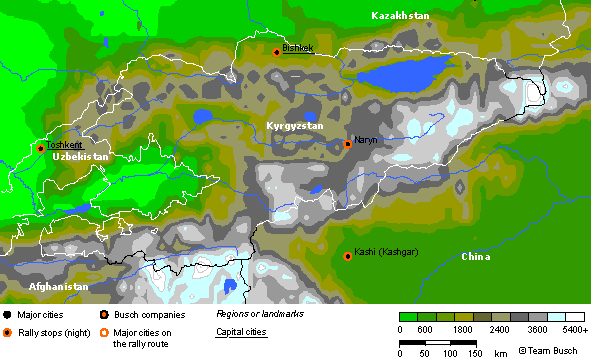
Route notes of the rally: …coming from Kazakhstan. Monday 22nd May - Day 22 — Tashkent to Bishkek 600km This long transit section crossing both Kazakhstan and Kyrgyzstan before arriving in Bishkek. Tuesday 23rd May - Day 23 — Bishkek to Naryn 340km The day starts with a one-kilometre sprint around a go-kart circuit stretched a little to accommodate the slightly larger cars of this event. Heading east towards the second highest lake in the World 'Ysys-Ko' the event winds its way over the Dolan Pass to reach Naryn. Wednesday 24th May - Day 24 — Naryn to Kashgar 360km This is a day to remember, an early morning start takes in the climb over the snow-covered Toragart Pass at 3800m before the descent on superb gravel roads into the border of China and Kashgar. …moving on to China. |