|
||||||||||||||||
 |
||||||||||||||||
|
|
||||||||||||||||
|
||||||||||||||||
|
|
Canada CanadaArea: 9,976,140 sq km |
|
Climate: varies from temperate in south to subarctic and arctic in northTerrain: mostly plains with mountains in west and lowlands in southeastElevation extremes: lowest point: Atlantic Ocean 0 m highest point: Mount Logan 5,950 mGeography—note: second-largest country in world (after Russia); strategic location between Russia and US via north polar route; nearly 90% of the population is concentrated within 160 km of the US/Canada border |
Population: 31,006,347 (July 1999 est.)Ethnic groups: British Isles origin 40%, French origin 27%, other European 20%, Amerindian 1.5%, other, mostly Asian 11.5%Religions: Roman Catholic 45%, United Church 12%, Anglican 8%, other 35% (1991)Languages: English (official), French (official) |
| In Canada, the BUSCH Vacuum Technics Inc. headquarters are located in Boisbriand, Québec (close to Montréal), and one factory service center is in Mississauga, Ontario plus two sales offices are in Vancouver and in the Maritimes. |
 |
|
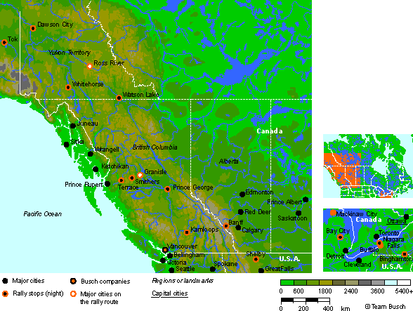
Route notes of the rally: …coming from the United States (Alaska). Tuesday 13th June - Day 45 — Tok to Dawson City 301km After turnoff on the Taylor Highway, Route 5, road becomes gravel and narrows on the way to Chicken. A STOP at the border into Dawson City and the Klondike atmosphere. Wednesday 14th June - Day 46 — Rest Day in Dawson City So you don't lose the competitive edge, a late morning jaunt to the Bonanza Creek gold discovery area. A 160km loop on nice gravel roads past dredges and former gold exploring sites. Back in Dawson for lunch and remainder of the day to explore the town and even gamble at The Diamond Gertie Gambling Hall. Thursday 15th June - Day 47 — Dawson to Whitehorse 606km Mostly highway driving crossing the Klondike, Pelly and Stewart Rivers. A small diversion along Frenchman Lake Road to Carmacks for lunch. Onwards to Whitehorse and end of day at the Transportation Museum, make sure to take time to visit the exhibit of the Alaska Highway construction. Friday 16th June - Day 48 — Whitehorse to Watson Lake via Ross River 736km A trek north on the Canol road, built during the construction of the North American Pipe Line to the Arctic oil fields. Gravel and narrow in places with majestic vistas and many animals evident. Lunch in Ross River and a blast down the Campbell Highway, wide and fast gravel to Watson Lake, the sign post capital of the North. Saturday 17th June - Day 49 — Watson Lake to Terrace 863km Long distance but mostly good paved road, Casiar Highway, Route 37. Lunch at Tatooga in Iskut B.C. Division via Nass Forest Service Road to Indian community of Aiyansh, past Kisumkalum Lake to Terrace B.C. Sunday 18th June - Day 50 — Terrace to Smithers with loop to Granisle 473km Winding Yellowhead Highway, Route 16, Hazleton via Kit'ga Road (gravel). After lunch in Smithers, a loop to Granisle and the Baine Lake mining and fishing district. Welcoming at Granisle Museum and Visitors Center for refreshment. More gravel roads back to Smithers. Monday 19th June - Day 51 — Rest Day in Smithers Downtown Main Street will be closed to display the cars. Local club to provide the facilities to do repairs. Hudson Bay Lodge will host a Cocktail reception for all the enthusiasts. Tuesday 20th June - Day 52 — Smithers to Prince George 531km Mostly gravel roads via Francois Lake to lunch at Fraser River on the Yellowhead Highway, Route 16. More interesting gravel roads via Butcher Flats, Punchaw and Baldy Hughes to Prince George. Many animals on the road, remain alert. Wednesday 21st June - Day 53 — Prince George to Kamloops 661km Reverse route to Baldy Hughes and onto Blackwater and Bouchie Lake. From Quesnel, route parallels the Fraser River on the east side to Williams Lake. After lunch, roads are narrower and more twisty and many elevation changes and exposures overlooking the Fraser River on the west side. On the way you pass through Alkali Lake, Dog Creek, Jesmond Clinton and Cache Creek to Kamloops. Thursday 22nd June - Day 54 — Kamloops to Banff 551km Mountain roads for 100km and then scenic Trans Canada Highway, Route 1, through the mountains, past 'Last Spike' historical site to Revelstoke, Rogers Pass and Golden to Banff. Lunch stoop is at Three Valley Gap by Three Valley Lake. Friday 23rd June - Day 55 — Rest Day on Banff Vintage and MG car clubs from Calgary will be available for repairs and assistance. Located in a National Park and a very touristy part of the Province of Alberta. Many activities and tours are available. Saturday 24th June - Day 56 — Banff to Shelby 642km Banff to the US border crossing along typical Canadian stage rally roads via Powderface Ridge, Gorge Creek and the Porcupines Hills. Mostly rolling hills in cattle country to lunch in Longview. Border crossing at Chief Mountain into the USA to St Mary and Glacier Park. The 'Road to the Sun' in Glacier Park was still 'snowed in' during the recce and hopefully will be open for the event next year. Highway drive using Route 89 and Route 2 to Shelby via Bowning. …moving on to the United States (Montana). …coming from the United States (Wisonsin). Monday 3rd July - Day 65 — Bay City to Niagara Falls, Ontario 557km Route meanders directly south east towards Port Juron through the towns of Vasser, Marlette and Dudley to the border crossing into the Province of Ontario, Canada at Sarnia. Route follows Thames River East to Glencoe for lunch along Lake Erie to Welland and Niagara Falls, Ontario. Tuesday 4th July - Day 66 — Rest Day in Niagara Falls On the US National Holiday, time to recoup before the final days to Newark. Lots to see and do with celebration fireworks in the evening. You can walk across the Rainbow Bridge to the US side but carry documentation. Wednesday 5th July - Day 67 — Niagara Falls to Binghamton 536km Late morning start
with run up to the Niagara Parkway to Queenston and border crossing
into the USA. Roads are mainly paved to the Cannonball Pub in Wyoming
via Tonawanda Creek, southeast past Letchworth State Park along the
Caniesteo River on Route 19. Nice roads in the Finger Lakes area of
upper New York State. An excursion into Pennsylvania, south of Corning
and Elmira before reaching Binghamton from the south. …moving on to the United Sates (New York). |